

Water Finder Technology (WFT™) gives exploration teams a faster, more focused way to screen greenfield and brownfield water and geothermal opportunities before committing to intensive field programs or drilling. Delivered through our technology partner CTAC OFT LLC (CTAC), WFT™ complements existing hydrogeological, geological and geophysical datasets, helping clients prioritise capital toward the most prospective subsurface targets.
A typical program can be completed in approximately 17 weeks, with an initial Phase 1 satellite assessment after around 8 weeks. This creates an early go/no-go decision point: clients can limit further expenditure where results are not compelling, or progress with greater confidence into field validation, modelling, well planning and further technical evaluation.
WFT™ applies multi-spectral electromagnetic response analysis to identify measured signal characteristics associated with subsurface water systems, including potential aquifers, fluid pathways, temperature and reservoir zones relevant to geothermal assessment. While the methodology may be unfamiliar to some exploration teams, it draws on established disciplines including electromagnetic geophysics, multi-spectral analysis, signal processing, pattern correlation and geophysical modelling — not to be confused with hyperspectral imaging. The technology has progressed through decades of research, testing and operational use, including more than 400 research and commercial projects, and is considered TRL-9 following sustained field application and evaluation by industry bodies.
As with all geophysical methods, WFT™ should be evaluated with scientific rigour and interpreted alongside hydrogeological understanding, thermal data and independent validation. For geothermal projects, WFT™ can help prioritise where to investigate fluid-bearing structures and reservoir potential, while drilling, temperature measurement, flow testing, geochemistry and reservoir modelling remain essential to confirm project viability. Prospective clients can assess the technology through Onirik and CTAC in a structured, confidential process, beginning with introductory material and a fit discussion, followed by an NDA for deeper technical information, case studies, validation examples and, where appropriate, client reference discussions.
Endorsements
MFT
-
UN Economic & Social Council for Economic & Environmental Best Practice
-
US Geological Survey (Pending)
OFT
-
National Hydrocarbons Commission of Mexico
-
National Resource Agency of Colombia
-
Darcy Partners

A technology proven over 30 yrs of ongoing research & 10+ yrs of successful projects
The individual scientific principles behind our partner, CTAC's Water Finder Technology (WFT™), are backed by more than 150 years of ongoing research. WFT™ and its sister technologies, MFT™ and OFT™ has come out of academic research on the synthesis of several scientific principles that has been ongoing for 30 years. Over the last 10 years more than 400 research and commercial projects have been successfully completed.
MFT™ and OFT™ have independent endorsement from the National Hydrocarbons Commission of Mexico, and the National Hydrocarbons Agency of Colombia, and the United Nations Economic and Social Council for economic and environmental best practice in exploration. And, CTAC, is currently working with the US Geological Survey, who are testing the use of the technology with a view to recommending it as best practice in resource exploration.

3 steps in 17 weeks


Tony Veitch
Chairman
Tec Minerals
The Wonogiri blind test has successfully demonstrated the potential for CTAC’s technology to accelerate exploration and lower the risk associated with exploration programs. We are confident in saying that CTAC's technology is a game-changer for the industry.
A precise technology that increases discovery success
rates in less time &
with less cost
The current model for water exploration starts with geology, to find indicators for the possible presence of water. This is followed by boring for water. They are increasingly deeper undercover, so, this geology based approach takes a long time – up to 18 months. This approach is expensive - costing up to tens of thousands of dollars per square kilometre explored. Finally, drilling success rates can be low – producing up to 50% dry bore holes. Water Finder Technology turns this existing paradigm around.
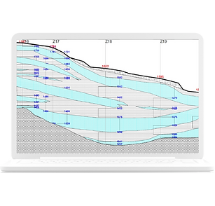
WFT™ first completes electromagnetic surveys of large areas, locating areas where there is underground water. In this first step, WFT™ can locate water beyond three kilometres deep, determine flows, water quality and temperature, and build a precision 3D model of your water reservoir and geology. WFT™ can do this within 17 weeks and, for areas sized above 100 square kilometres, for total costs below traditional geological methods. The second step moves directly to drilling highly targeted bore holes, at optimum tapping points, and has a historic strong success rate for producing water.
Water Finder Technology provides a shorter and lower cost exploration sequence that is one step from remote and field data collection to a highly targeted drilling program.


FAQs
Is MFT™, OFT™ & WFT™ limited by the skin effect?
MFT™, OFT™, and WFT™ are not probing with active signals to survey below the Earth’s surface. The technology is passive and measuring changes to the Earth’s electric, magnetic, and electromagnetic fields at the boundary between the lithosphere and the atmosphere. Therefore, it is not limited by the typical skin effect, attenuation, and wavelength issues in ground penetrating radar and active electromagnetic geophysics.
What is the certainty, or confidence, one can have in resource maps built my MFT™, OFT™ or WFT™?
After Phase 1, the remote satellite step, if MFT™ says minerals are present, or OFT™ says oil or gas or WFT™ says water is present, there is confidence that there is a resource present. Phase 1 is a wide area low precision survey. It does not delineate all the details of the orebody or reservoir structure.
Can we do just the Satellite Phase, or the Field Phase?
It is not necessary to do all steps of the exploration in the sequence 1 - 2 - 3 i.e. remote satellite, field, laboratory data integration, analysis and report generation. But we recommend it if you want the precision to plan your drilling campaign.
No environmental disturbance & no permits required
Most alternate electromagnetic and seismic technologies (the ones that actually explore below the surface) are active, sending signals into the earth’s crust, lakes, or oceans. Water Finder Technology is a passive technology because it is measuring changes in the earth’s electromagnetic field (at the earth-atmosphere boundary).
In each phase of WFT™ it is measuring the static field, or artificially varying the magnitude of the electromagnetic field of the earth, at the resonant frequencies of the materials of interest, at a given point. The polarised layers in the atmosphere, that exist in response to the subsoil reservoirs, respond to that, and the WFT™ equipment measures the characteristics of static field and response fields.
When we talk with clients, we generally discuss depths up to 3 kilometres for water bearing rock because depths beyond 2 kilometres can present significant technical and economic challenges that make water extraction unfeasible.
Oil and Gas Finder Technology, the oil and gas cousin of WFT™, that uses the same technology, has explored to depths of 9.8 kilometres.
Recent Posts


In the media
Mine Australia


thebusiness|year


