

Mineral Finder Technology (MFT™) gives exploration teams a faster, more focused way to screen greenfield and brownfield opportunities before committing to intensive field programs or drilling. Delivered through our technology partner CTAC OFT LLC (CTAC), MFT™ complements existing geological and geophysical datasets, helping clients prioritise capital toward the most prospective targets.
A typical program can be completed in approximately 17 weeks, with an initial Phase 1 satellite assessment in 8 weeks. This creates an early go/no-go decision point: clients can limit further expenditure where results are not compelling, or progress with greater confidence into field validation, modelling, drill planning and formal reporting pathways such as NI 43-101.
MFT™ applies multi-spectral electromagnetic response analysis to identify measured signal characteristics associated with target minerals. While the methodology may be unfamiliar to some exploration teams, it draws on established disciplines including electromagnetic geophysics, multi-spectral analysis, signal processing, pattern correlation and geophysical modelling - not to be confused with hyper-spectral imaging. The technology has progressed through decades of research, testing and operational use, including more than 400 research and commercial projects, and is considered TRL-9 following sustained field application and evaluation by some industry bodies.
As with all geophysical methods, MFT™ should be evaluated with scientific rigour and interpreted alongside geological understanding and independent validation. Prospective clients can assess the technology through Onirik and CTAC in a structured, confidential process, beginning with introductory material and a commercial fit discussion, followed by an NDA for deeper technical information, case studies, validation examples and, where appropriate, client reference discussions.
Endorsements
-
UN Economic & Social Council for Economic & Environmental Best Practice
-
US Geological Survey (Pending)

Pilot Project
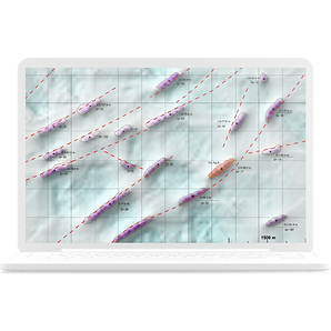
Gold in Indonesia


Tony Veitch
Chairman
Tec Minerals
The Wonogiri blind test has successfully demonstrated the potential for CTAC’s technology to accelerate exploration and lower the risk associated with exploration programs. We are confident in saying that CTAC's technology is a game-changer for the industry.
A technology proven over 30 yrs of ongoing research & 10+ yrs of successful projects
Our partner CTAC's, Mineral Finder Technology (MFT™) and Oil & Gas Finder Technology (OFT™), have been used in over 400 research & commercial projects to date. OFT™ has been used successfully in the petrochemical industry for decades. In the last decade MFT™ has been adopted in the mining industry exploring iron, coal, anthracite, nickel, gold, platinum, copper, zinc, silver, lead, chromite to name just a few.
Our mineral and oil & gas partner, CTAC, have a complete library of the resonant frequencies for the naturally occurring elements (ie. the periodic table) and mineral compounds of interest (ie. elements as they occur in nature) for mining and oil & gas exploration.
A precise technology that increases discovery
success rates
With the dwindling number and quality of mineral resources mineral exploration requires high investment, sustained cash inflow, and considerable time, with inherent high risk – where risk is defined as chance of failure or loss.
Exploration uncertainty and risk reduction can be addressed in three fundamental ways. Increase:
-
the number of examinations;
-
success probabilities; and
-
success probabilities per study by learning.
Mineral Finder Technology addresses all factors by reducing the time and cost to assess, so more examinations of large areas can be conducted, improving the accuracy of assessments to focus only on economically viable areas thereby increasing the success probability, and applying machine learning to each project so algorithms constantly improve.

3 steps in 17 weeks


FAQs
Given you have a “mineral fingerprint database”, is it plausible to complete blind scans?
Yes. If we can complete all three phases of the MFT™ project, the confidence on the findings is high. Mineral samples are not necessary, rather they are a nice to have.
How many minerals can MFT™ search for at the same time, or in one project?
In each step of the process, MFT™ surveys for one resonance signature. Therefore, in searching for 10 minerals compared to searching for one mineral, there would be nearly 10 times more remote, field, and laboratory work.
Can we do just the Satellite Phase, or the Field Phase?
It is not necessary to do all steps of the exploration in the sequence 1 - 2 - 3 i.e. remote satellite, field, laboratory data integration, analysis and report generation. But we recommend it if you want the precision to plan your drilling campaign.
Investing in MFT™ reduces your total costs to discovery
With dwindling near-surface resources, the search has moved to deep seated deposits increasing drilling costs. The skin effect, at depth compromises active seismic and electromagnetic technology accuracy. Environmental compliance regulations are also increasing in complexity and lifting exploration costs.
Mineral Finder Technology is a passive technology that can give you high confidence for the minerals present, the grade, location and depth. This can result in an exploration process with one step from MFT™ data to a targeted drilling program. Mineral Finder Technology can deliver a reduction of total exploration steps or can be integrated with other workflows easily to increase confidence of drilling target datasets even further.
Advanced technology that provides faster turn-arounds
The typical Mineral Finder Technology exploration project takes 17 weeks to complete, for the remote satellite work, onsite field work, and final report generation.
The project phases make up the total time as follows:
-
Remote satellite data analysis and report generation = 8 weeks.
-
Field work data capture and analysis = 4 weeks.
-
Laboratory data integration and final report generation = 5 weeks.
Very large areas, for example - 200,000 sq km, and a shopping list of minerals to be located can extend the time.
Case Studies
Gold, Copper & Silver in Mexico
Click here to watch video
Gold in Latin American
Click here to watch video

Recent Posts


No environmental disturbance & no permits required
Most alternate electromagnetic and seismic technologies (the ones that actually explore below the surface) are active, sending signals into the earth’s crust, lakes, or oceans. MFT™ is a passive technology because it is measuring changes in the earth’s electromagnetic field (at the earth-atmosphere boundary).
In each phase of Mineral Finder Technology it is measuring the static field, or artificially varying the magnitude of the electromagnetic field of the earth, at the resonant frequencies of the materials of interest, at a given point. The polarised layers in the atmosphere, that exist in response to the subsoil mineralisation, respond to that, and MFT™ equipment measures the characteristics of static field and response fields.
When we talk with mineral mining clients, we generally discuss depths up to 3 km for minerals in concentrations of 50 – 100 ppm because lower grades and depths beyond 2 km can present significant technical and economic challenges that make mining unfeasible.
OFT™, the oil and gas cousin of MFT™, that uses the same technology, has explored to depths of 9.8 km.
Our ongoing support helps you maximise ROI & project success
The fourth phase is the support phase. After the client receives the engineering report they usually move to a highly targeted and minimal drilling campaign.
With Mineral Finder Technology projects clients gather cores to verify the ore bodies are at the location, depth and grade forecast in the MFT™ report. For OFT™ this is to verify the reservoirs of oil, gas, or condensate are at the locations, depths and pressures forecast in the OFT™ report.
In all engagements, during the drilling program CTAC provide technical support on-site, and from the laboratory. For example, the CTAC team may use their proprietary field equipment to take measurements (VERS) at a proposed drill point, before the drilling is done, to ensure the drilling proceeds in the right place.
CTAC also provide ongoing laboratory and field support during the subsequent construction, and operation phases for no additional cost, except travel.
In the media
Mine Australia


thebusiness|year


